![Item #3700 [Small Archive of Correspondence and a Large Township Map Relating to Land Speculation in Nemaha County, Kansas]. Kansas, Jeffrey Sage, Land Speculation.](https://mcbriderarebooks.cdn.bibliopolis.com/pictures/McBRB3700.jpg?width=768&height=1000&fit=bounds&auto=webp&v=1678722549)
[Small Archive of Correspondence and a Large Township Map Relating to Land Speculation in Nemaha County, Kansas]
[Various locations: 1861-1868]. Eleven related letters to the Sage family dated 1861-1868. Various sizes. Generally minor wear. [with:] Printed map, 27.5 x 19.5 inches. Minor toning, partial separations at folds, otherwise minor wear. Very good. Item #3700
A grouping of retained correspondence and a large promotional map relating to Kansas real estate speculation during and just after the Civil War. The letters were written to Jeffrey Sage (1791-1876) and his son William N. Sage (born 1828) of Broome County, New York and Virginia, who had invested in land in Nemaha County in northeastern Kansas, apparently in the now-defunct village of Albany just north of Sabetha. These letters from their agents and friends in Kansas offer some interesting details on frontier conditions there during the Civil War era. John L. Graham writes on January 6, 1861: "Miller is out on the Republican Fork of the Kansas River, hunting and trapping.... There are three houses in Albany and a steam sawmill in prospect, no school house and no school, no store. There are nine houses in Sabetha, no school house, but they have a school in the log house on the corner and have 30 schollars. There is a good blacksmith there, and he has a pleanty of work. He has two marriageable daughters and Bill Graham waited on one of them to meeting down to Albany yesterday."
Edwin Miller wrote from Missouri on August 19, 1865: "I have not lived in Kan. since the war commenced. I was in the service 2 yrs, was lieut. in the Kans. 7th Cavalry.... Albany has got the P.O. away from Sabatha since I left. There is no store in Sabetha, 2 in Albany." He also lists the residents of Albany. Another correspondent, J.C. Hebbard, a resident of Seneca since 1860, sent his report on February 14, 1866, describing the businesses in Seneca and Albany, and anticipating "quite a large emigration to Kansas this year." Hebbard's gilt-accented letterhead from 1868 has a long promotional message regarding Nemaha County printed on verso, and his August 15, 1868 letter boasts of Albany's "two stores and a very fine school building." A very nice collection of letters with solid research potential.
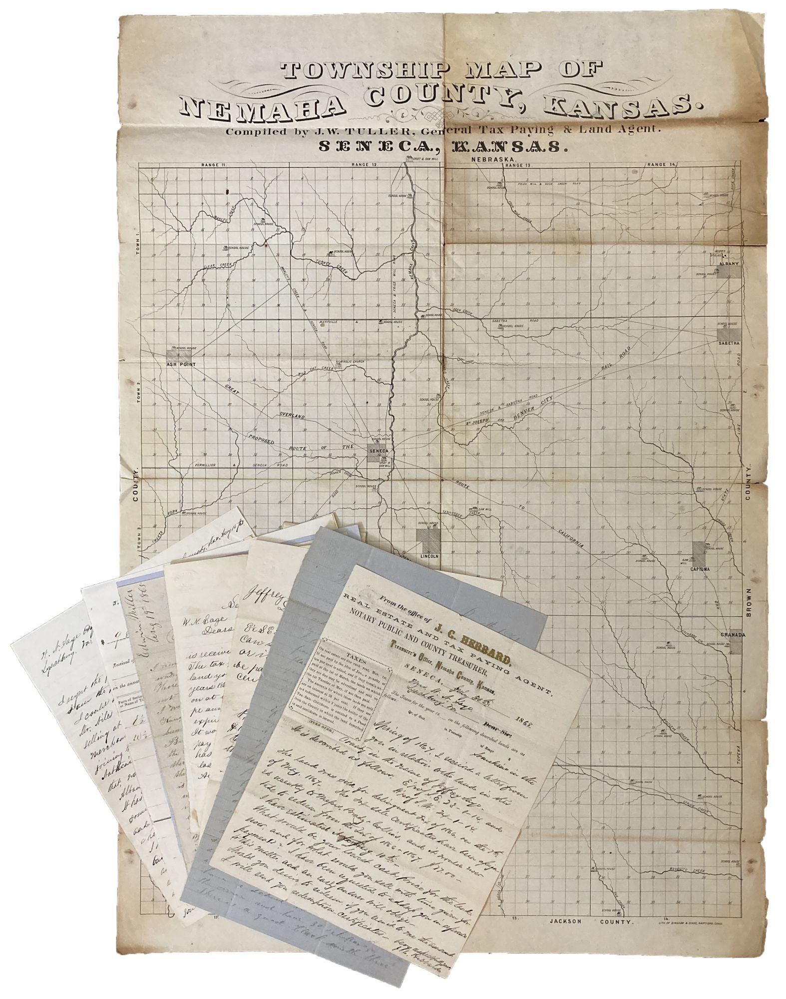
In addition to the letters, the collection includes a striking, and seemingly unrecorded, cadastral map entitled, "Township Map of Nemaha County" by J.W. Tuller, described at the top of the map as "General Tax Paying & Land Agent" in Seneca, Kansas. The map was produced in Hartford by Bingham & Dodd, likely between 1861 and 1866. This substantial map shows a proposed railroad (completed in 1866), settlements, school buildings, saw and grist mills, and the famed Overland Trail (here marked as "Great Overland Route to California"). A small square just north of Albany is marked in red ink, probably the land owned by the Sage family. We could locate no other examples of this map in OCLC. A wonderful grouping of letters and a map which provide insight into the development of a small Kansas community in the midst of the Civil War and just afterwards.
Price: $5,500.00