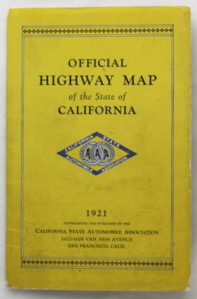
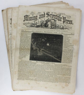
Highway Map of the State of California Prepared and Copyrighted by the California Automobile Association
San Francisco: 1921. Folding map, 41.75 x 16 inches. Folded into card covers, 8.5 x 5.5 inches. Minor wear to map, light rubbing and wear to covers. A large folding map of the state of California showing primary highways, secondary and tertiary roads, rivers, borders, and railroads. Useful for navigating..... More
![Item #725 Denny's Pocket Map of Lake County California 1904 [caption title]. California](https://mcbriderarebooks.cdn.bibliopolis.com/pictures/McBRB725_01.jpg?width=320&height=427&fit=bounds&auto=webp&v=1563022241)
![Item #2022 E-Z Guide Map of Los Angeles [cover title]. California](https://mcbriderarebooks.cdn.bibliopolis.com/pictures/McBRB2022_01.jpg?width=320&height=427&fit=bounds&auto=webp&v=1631198292)
![Item #673 Have You Been to Santa Cruz County? [cover title]. California](https://mcbriderarebooks.cdn.bibliopolis.com/pictures/McBRB673_01.jpg?width=320&height=427&fit=bounds&auto=webp&v=1562761192)
![Item #309 Monrovia "Gem of the Foothills" California [cover title]. California](https://mcbriderarebooks.cdn.bibliopolis.com/pictures/McBRB309_01.jpg?width=320&height=427&fit=bounds&auto=webp&v=1550245714)
![Item #2673 [Panoramic Photograph of the Downtown Commercial District in Midcentury San Mateo]....](https://mcbriderarebooks.cdn.bibliopolis.com/pictures/McBRB2673_01.jpg?width=320&height=427&fit=bounds&auto=webp&v=1686230599)
![Item #679 Placer County, California. The Land of Sunshine, Fruit & Flowers [cover title]. California](https://mcbriderarebooks.cdn.bibliopolis.com/pictures/McBRB679_01.jpg?width=320&height=427&fit=bounds&auto=webp&v=1562628762)
![Item #1015 Portfolio Containing Choice Views of California [cover title]. California](https://mcbriderarebooks.cdn.bibliopolis.com/pictures/McBRB1015_01.jpg?width=320&height=427&fit=bounds&auto=webp&v=1576676020)
![Item #684 Santa Rosa, California. Home of Luther Burbank [cover title]. California](https://mcbriderarebooks.cdn.bibliopolis.com/pictures/McBRB684_01.jpg?width=320&height=427&fit=bounds&auto=webp&v=1562761192)
![Item #677 The Sign of the Arrowhead. Arrowhead Hot Springs. Arrowhead, California [cover title]....](https://mcbriderarebooks.cdn.bibliopolis.com/pictures/McBRB677_01.jpg?width=320&height=427&fit=bounds&auto=webp&v=1562628762)
![Item #2035 Souvenir of San Francisco Compliments of E.H. Kittredge & Co. [cover title]. California](https://mcbriderarebooks.cdn.bibliopolis.com/pictures/McBRB2035_01.jpg?width=320&height=427&fit=bounds&auto=webp&v=1634223812)
![Item #665 Street Map, City of Belmont, California [caption title]. California](https://mcbriderarebooks.cdn.bibliopolis.com/pictures/McBRB665.jpg?width=320&height=427&fit=bounds&auto=webp&v=1564256206)
![Item #1795 Vistas de Long Beach [cover title]. California](https://mcbriderarebooks.cdn.bibliopolis.com/pictures/McBRB1795_01.jpg?width=320&height=427&fit=bounds&auto=webp&v=1612531019)
![Item #715 Weber's Map of Sierra County California [cover title]. California](https://mcbriderarebooks.cdn.bibliopolis.com/pictures/McBRB715_01.jpg?width=320&height=427&fit=bounds&auto=webp&v=1561595457)