
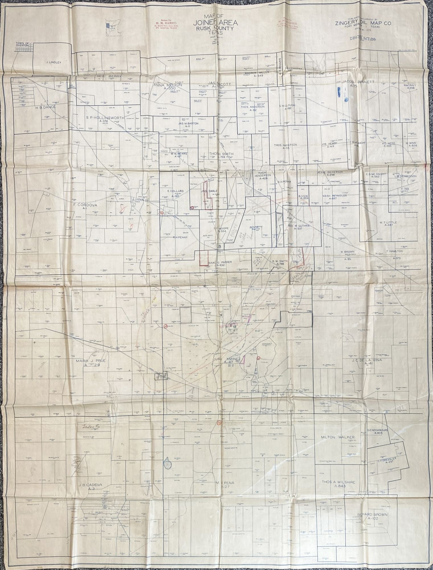
Map of Joiner Area Rusk County Texas
Abilene, Tx. Zingery Oil Map Co., [ca. 1930s]. Blueline map on drafting linen, approximately 54 x 41 inches. Minor wear, contemporary pencil notations. Very good. Item #2483
A substantially-sized and seemingly unrecorded Texas oil map featuring the Joiner oilfields in Rusk County, Texas, the first known map to show the Joiner Subdivision, with oil wells, claim ownership, and much other important information. C.M. “Dad” Joiner leased this subdivision from the widow Daisy Bradford in August 1925, obtaining a lease on widow Daisy Bradford's 975 acre farm; the map shows the three "Daisy Bradford" wells in pencil. Joiner then moved to Rusk County in 1926. Joiner and his crew drilled for three years beginning in 1927, using a flimsy pine rig and battered tools, trying their luck about six miles northwest of Henderson. The first two wells came up dry, but in 1930 the third struck the largest oil deposit discovered to that time and became one of the richest oil fields in the country, let alone Texas. This field is noted as “Joiner et al. 975 Ac. in Lse” on the Joiner Subdivision of the map.
Rusk County is located in the Piney Woods of East Texas, about 120 miles southeast of Dallas. The present map shows the county divided into the tracts of its various land owners, including the Hugh Henderson and Juan Ximenez surveys, and the Andrew Miller survey, which became Joinerville. Numerous plots are noted as belonging simply to "Joiner." A previous oil speculator has made numerous notations and scribblings in the body of the map, with the word "ROYALTY" prominently written in an area of land owned by Neal Cooper. Also, a handful of times, the speculator has circled the dot where the name Joiner appears. There are also many different leases and ownership situations shown on the map, including joint ownerships, land ownership of “Mrs. Daisy Bradford 928 A.”, “Humble [later Exxon] 2/6," Gulf Oil 1/6," “Lloyd Oil Co.," “Joiner 30 Ac.," “Osborn (W.B. Osborn Oil & Gas) 50 A. / Joiner 30A.," “Sun Oil," “Arkansas Fuel Oil Co," and others.
C.M. Joiner had an exclusive contract with the Zingery Oil Map Co. to produce this map, noting it as “COPYRIGHTED,” an unusual phenomenon for Zingery. This map is in fact marked “Published Exclusively by Zingery Oil Map Co.” and “REGISTERED No. 976.” There is also a warning to copyright infringers reading: “Notice. The map is copyrighted. Any person copying by photostat or other means is infringing, and will be prosecuted to the full extent of the Law.”
"Between 1930 and 1936 Rusk County's population mushroomed from 32,000 to 65,000, as oilfield workers, wildcatters, speculators, lawyers, and other opportunists arrived to take advantage of the find. The discovery of oil not only changed the composition of the population but altered the very appearance of the area. New towns such as Joinerville, Carlisle, New London, and Turnertown sprang up; established settlements changed from rural communities to bustling boomtowns. Numerous new hotels, offices, and oil-related businesses were built in and around Henderson. Oil derricks and pumps soon dotted the countryside. Henderson, formerly a sleepy county seat, was transformed into a busy center of activity. Between 1930 and 1940 the town's population grew from 2,932 to 6,437. Though once something of an agricultural backwater, Rusk County overnight became a scene of conspicuous wealth, where the average household income far exceeded the statewide average" - Handbook of Texas online. No copies in OCLC.
Price: $2,500.00