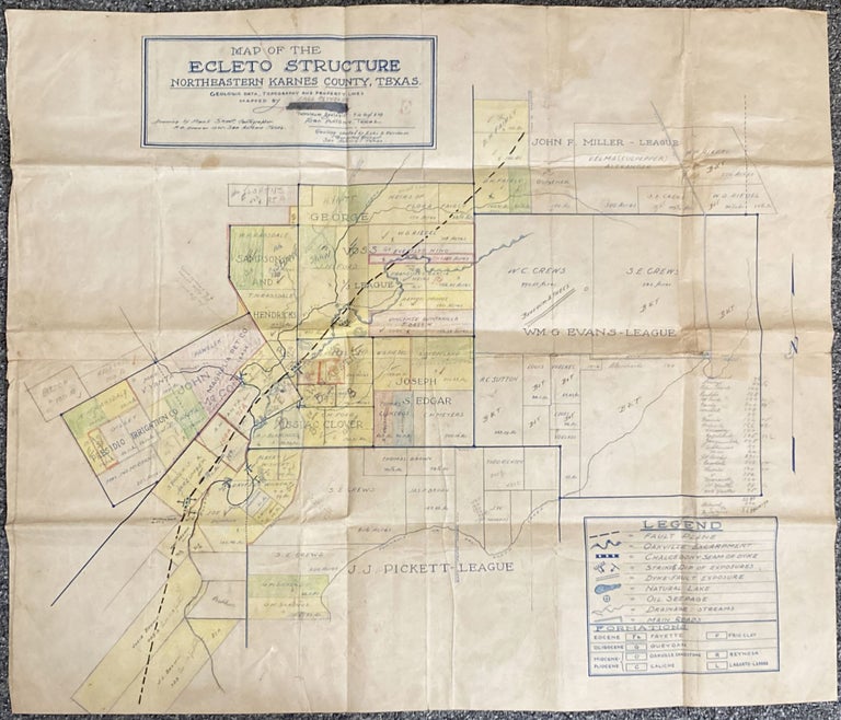
Map of the Ecleto Structure Northeastern Karnes County, Texas
San Antonio: ca. 1930s]. Blueline map, 25 x 29.5 inches. Old folds, minor soiling, some hand-coloring, extensive pencil and ink annotations. Numerous masking tape reinforcements to verso. About very good. Item #2301
A substantially annotated Texas cadastral map focused on the Ecleto Structure southeast of San Antonio and northwest of Corpus Christi. The map shows land ownership and development in Karnes County, with the "Geologic data, topography and property lines mapped by Early Reynolds" (his name penciled in after previous name scratched out). In 1921, Walter G. Riedel (his name is on the list of the residents on the map) and others built a cooperative store and cotton gin at Ecleto to serve the surrounding farm community. A post office opened in the store in 1921. The Presidio Irrigation Company is listed as an owner or leaser of a handful of tracts, indicating their hand in the development of the town. There is also a lease from the Magnolia Petroleum Company on the map, as well as several items listed in the map’s key indicating oil was present or being sought for in Ecleto during this time. Most of the land tracts in the western half of the map are colored by hand, with names of new owners, newly-drawn boundary lines, additional plots of land added in pencil to the western extremities of the town, and other notes. No copies of the present map are listed in OCLC.
Price: $1,500.00