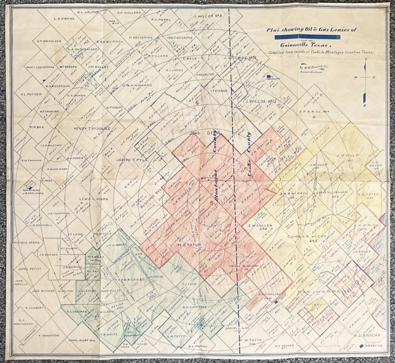
Plat Showing Oil & Gas Leases of Gainesville Texas. Compiled from records of Cooke & Montague Counties Texas
Gainesville, Tx. W.W. Howeth Co., [ca. 1920s]. Blueline map, 27 x 29 inches. Old folds, very short separations to some fold lines, most reinforced with archival repairs on verso. Extensive hand coloring and some pencil notations. About very good. Item #2086
A rare and seemingly unrecorded cadastral map showing land ownership and mineral rights along the north-south borderline between Montague and Cooke counties in far northeast Texas. The oil properties were divided between major companies such as Foster, Vacuum, Texas (Texaco), Humble, Gulf, Sunoco, and Pure, evidenced by numerous pencil annotations added to the map, especially in the hand-colored sections. The map was produced at the behest of the W.W. Howeth Company in Gainesville, a title and escrow company which remains one of the longest-running companies in Texas. In addition to the oil content, the map is useful as a snapshot of overall property ownership in the area, with hundreds of plats drawn by owner and noting the acreage of each; among the multiple dozens of private owners are the Southern Pacific Railroad and the Buffalo Bayou, Brazos & Colorado Railroad Company. We could locate no copies in OCLC.
Price: $1,500.00